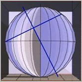
Flat Earth
A large circle lies on the Earth, with its northern axis point located near 138° west longitude and 60°
north latitude, rounded to the nearest degree. The circumference of this globe circle is approximately
24882 miles. A number of ancient structures were placed around the perimeter of this circle.
The implication is that this was done to communicate important and accurate information.
Who placed these structures there, and for what purpose?

The image on the left is an azimuthal projection centered on the north pole axis. The image on the right
is an azimuthal projection centered on the northern axis point in northwestern British Columbia, Canada.
In an equal azimuthal projection, all distances from the center are represented proportionally. Since the
sites in this great-circle alignment are each one quarter of Earth’s circumference from the axis point, the
alignment appears as a perfect circle halfway between the center and the outer edge of the projection.
The distinction between the two projections is as follows: a heliocentric or globe model produces the
perfect circle in green, while an azimuthal projection centered on the north pole axis produces a distor-
ted circle. By contrast, an azimuthal projection centered on 138° west longitude and 60° north latitude
produces a perfect circle in red and green. Using this projection yields the result shown below.
Strikingly, the crosshairs fall exactly where the heliocentric south pole is located in Antarctica.
This suggests that both geo and heliocentric models have been presented to us, though only one
is correct. It points to a key in the form of a cross, fitting the lock of a flat, nonrotating Earth.

Antarctica, situated centrally, touches all four quarters. It is possible that the other three quarters each
contain their own sun and moon. The blue cross, where the ratio of vertical to horizontal measurement
is 1.25, reveals several notable numbers: 138 + 60 = 198; 198 × 2 = 396; 396 / 125 = 3.168.
The same cross design also appears in the Stonehenge drawing.
Three notable facts are associated with the number 3168:
first, the value of “Lord Jesus Christ” in Greek numerics is 3168;
second, the diameter of our North quarter circle, 24882 miles / π, equals 7920, and 7920 × 4 = 31680;
third, he was born southeast of Bethlehem at latitude 31.68° north.
The implication is that the sun may be nearby and relatively small, perhaps with a diameter of 31.68 miles.
It may be projected into our realm from a larger source, like light passing through a magnifying glass to form
a concentrated hot point.
The circumference of our circle in the north quarter is derived from a known measurement on the map.
Dividing the circle’s diameter by that measurement yields a number of segments. Multiplying the known
measurement by the number of segments and π yields an estimated circumference of about 78167 miles.
What continents or lands exist in the east, south, and west quadrants? Who or what inhabits them?
Perhaps “extra-terrestrials,” meaning other land-dwellers, who are technologically far ahead of us.
An excerpt from *The Iron Republic* states: “This,” he replied, “is the Iron Republic and the continent
on which you stand lies about as far from the frozen ocean as your own continent of America does in the
opposite direction.” Iron symbol: Fe.
Great Pyramid to Polaris — Check this out first
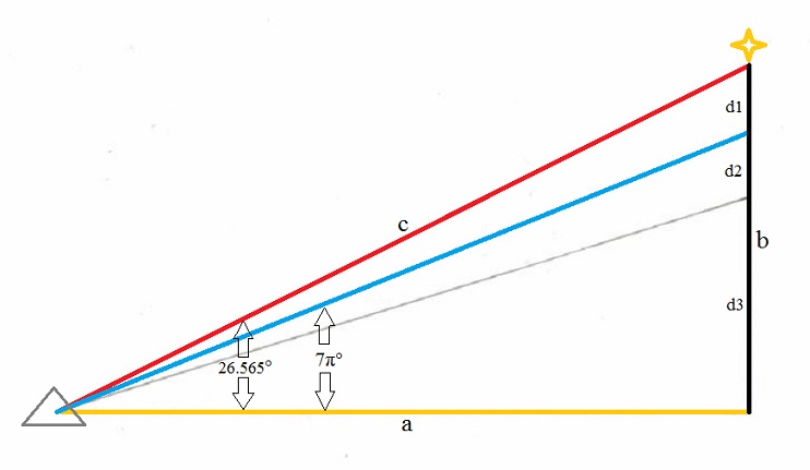
Several interesting numerical and geometric relationships appear:
- Line “a” from the Great Pyramid to the true geographic center of the greater realm "Y" is 16588 miles.
- Line “b” is 8294 miles.
- a² (275161744) + b² (68790436) = c² (343952180)
- d1 (1584 mi) + d2 (1584 mi) = 3168 miles
- Line “b” (8294 mi) divided by 3168 = φ 1.6180...
- Line “b” (8294 mi) divided by d3 (5126 mi) = φ 1.6180...
- d3 (5126 mi) divided by d1 + d2 (3168 mi) = φ 1.6180...
- The yellow line represents a thickness of c / (d1 + d2) × 12.5 = 73.17... miles
The diameter of our North quarter circle is 24882 miles:
- 24882 / a = 1.5
- 24882 / b = 3
- 24882 / c = √1.8
Additional features:
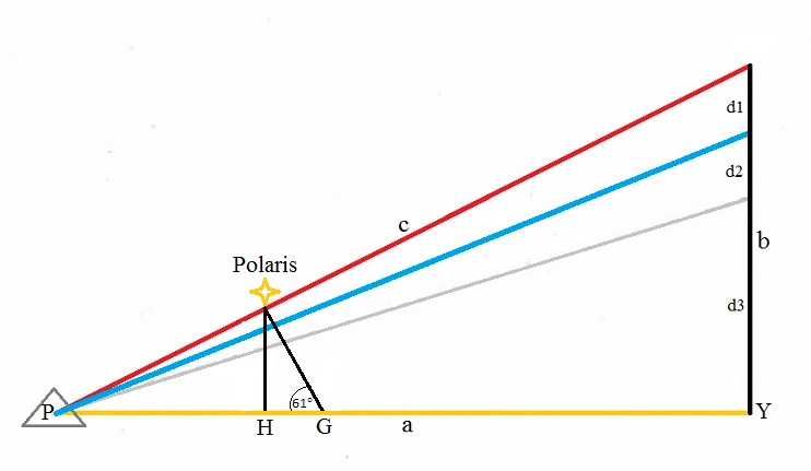
- "G" marks the intersection of the cross and the true center of the north quarter circle at 138° west
- longitude and 60° north latitude, from which the G line points up to Polaris at nearly 61 degrees.
- Line GY 10252 miles divided by line PG 6336 miles = φ 1.618...
- Line PH 4964 miles divided by line HG 1372 miles = 3.618...
- The descending passage in the Great Pyramid pointing to Polaris is indicated by the red line.
- Pointing up to Polaris from the true center of the north-quarter circle "G" at 60°N latitude is 61 degrees.
- Pointing up to Polaris from "H" in the North Pole heliocentric global model.
- All three lines converge on Polaris.
According to this model, all stars, planets, and other celestial bodies orbit Polaris in coordinated motion
above a stationary, flat Earth. This celestial circle Is obviously much larger than we are familiar with.
A slight adjustment and a possibility to consider:
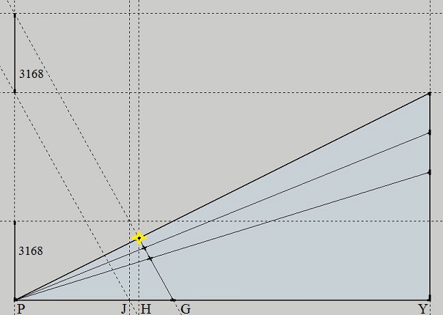
JY Line divided by PJ line = 2.618...
PJ line divided by JG = 2.618...
Perhaps J Is the helio-centric North Pole, and In that case Polaris would not be directly overhead.
Imagining the four quarters idea as a mechanical, clock or electrostatic/magnetic device
Exploratory ideas — patterns inviting thought, not proven facts. Somebody with
electrostatic/magnetism experience should explore the following ideas further.
The North Quarter
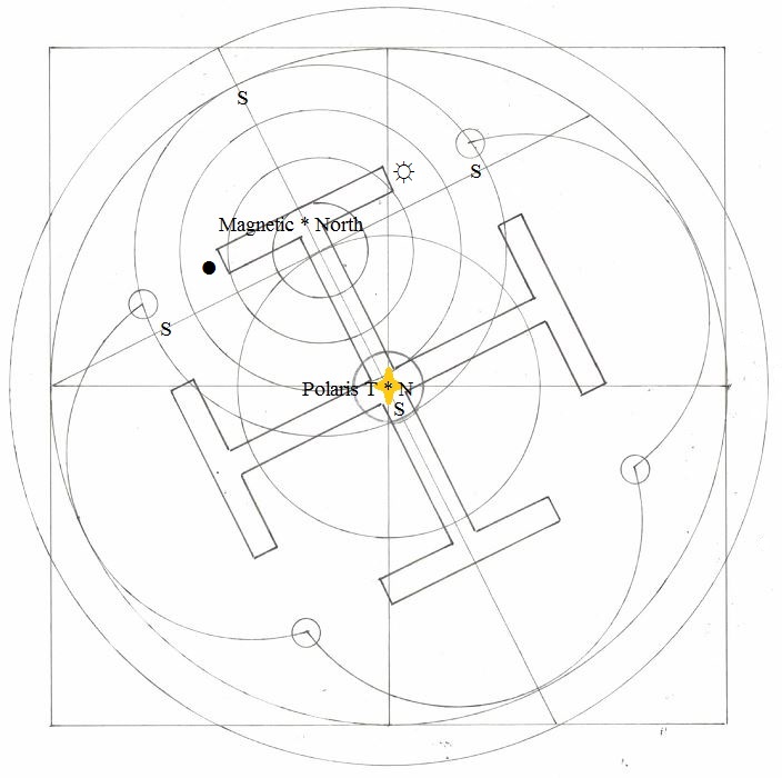
In this view, the north quarter has a magnetic north, and all directions away from it are south. If each of
the four quarters has its own sun and moon, then the 24-hour sun some claim to observe in Antarctica
may instead belong to another quarter and circle near true north.
This suggests the possibility that we are viewing only a smaller section of a much larger plane, perhaps
with domes within domes and lights projected or refracted into them from an original source.
It was claimed, to reach the true geographic center of the greater realm, one must travel south, where
compasses allegedly fail; it is reached through celestial navigation. An excerpt from Inventio Fortunata:
“Here the ship’s compass loses its property and no vessel with iron on board is able to get away.”
Compare this four corners pattern with the electromagnetism and polarity model N/S & +/-

We may have to rethink a few things!
Luminaries in a clear dark night, standing firm defying tyranny.
Precede us to the morning light, our golden age of opportunity.
In my opinion the best flat earth information site flatearthdave.com